
Nazca
Know more about Nazca
Located on Peru's southern coast, Nazca is a destination that defies logic and time. World-famous for the enigmatic Nazca Lines—giant geoglyphs etched into the desert floor—this city is a living museum of ancient astronomy. It is the ideal place for history and mystery lovers seeking to fly over colossal figures and explore one of the most ingenious civilizations of the pre-Hispanic world.
Ancient Mysteries and Desert Oases
- Lines Overflight: View figures like the Monkey, Hummingbird, and Astronaut from the air, declared a UNESCO World Heritage site.
- Cahuachi: The world's largest mud ceremonial center, the spiritual heart of the Nazca culture.
- Chauchilla Cemetery: A unique archaeological site where ancient mummies and textiles are preserved in their original location.
Best Time to Visit Nazca
Nazca is sunny year-round (68°F to 90°F). The best time for overflights is between May and October, when winds are moderate and the sky is perfectly clear, ensuring impeccable visibility of the geoglyphs from the aircraft.
See more
See less
Located on Peru's southern coast, Nazca is a destination that defies logic and time. World-famous for the enigmatic Nazca Lines—giant geoglyphs etched into the desert floor—this city is a living museum of ancient astronomy. It is the ideal place for history and mystery lovers seeking to fly over colossal figures and explore one of the most ingenious civilizations of the pre-Hispanic world.
Ancient Mysteries and Desert Oases
- Lines Overflight: View figures like the Monkey, Hummingbird, and Astronaut from the air, declared a UNESCO World Heritage site.
- Cahuachi: The world's largest mud ceremonial center, the spiritual heart of the Nazca culture.
- Chauchilla Cemetery: A unique archaeological site where ancient mummies and textiles are preserved in their original location.
Best Time to Visit Nazca
Nazca is sunny year-round (68°F to 90°F). The best time for overflights is between May and October, when winds are moderate and the sky is perfectly clear, ensuring impeccable visibility of the geoglyphs from the aircraft.
The tours our customers prefer in Nazca
Discover the ultimate itineraries and travel packages in Nazca. Embark on a true adventure with our expert guides and experience the authentic soul of the Central Andes.

Flight Over the Nazca Lines
Book with total security the Nazca Lines Tour today. Enjoy a spectacular overflight above the millennial geoglyphs representing geometric figures, animals, and plants in the Ica desert. Get informed about our daily departures and take advantage of exclusive offers to discover this mysterious destination in southern Peru. Nazca awaits you with the enigmas of an ancient civilization etched over a 500-square-kilometer plain with the best professional organization and expert local guides for your unforgettable journey!

Chauchillas Cemetery
Visit the archaeological necropolis of Nazca on an exciting Full Day Tour to the Chauchilla Cemetery. Discover this millennial site where you will find extraordinarily preserved mummies and fascinating artifacts from an ancient culture. Get informed and book with total security to explore the mysteries hidden within this world-unique pre-Inca cemetery. Take advantage of our exclusive offers and secure your spot with certified expert guides today! Nazca awaits you with its enigmatic history and an unforgettable archaeological adventure.
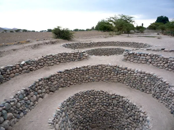
Aqueduct of Cantayo and Paredones
The Cantayoc Aqueducts feature underground water channels that have surprised the entire world with their advanced hydraulic engineering. Visit this incredible destination and discover how the ancient Nazca Culture managed to conquer the desert through unique irrigation systems. Get informed and book with total security to explore these millennial structures with specialized local guides today. Take advantage of our exclusive offers and secure your spot on this unforgettable adventure tour. Nazca awaits you with its fascinating historical legacy!

Usaca Sand Buggy & Sandboarding
Enjoy the rush of off-roading and sandboarding along the great sand dunes of the Nazca desert while visiting sites thousands of years old with Inca World Travel. Get informed and book with total security to explore the sacred city of Cahuachi and Estaqueria, key locations for understanding the mysterious Nazca Civilization today. Take advantage of our exclusive offers and discover the secrets of the famous mummies and the marks left along the desert floor. Ica awaits you with adventure and expert local guides!

Sandboarding in Cerro Blanco
Adventurous traveler, enjoy sandboarding at Cerro Blanco in Nazca with Inca World Travel and guaranteed fun. Get informed and book with total security to slide down the world's largest sand dune, standing at approximately 2,070 meters high, today. Take advantage of our exclusive offers and marvel at the stunning views of the Nazca Valley from this sacred site. Ica awaits you with pure adrenaline and the longest sandboarding descent available on the planet, accompanied by our expert local professional guides!
What you should know about - Nazca
The geography of Nazca is situated in one of the most arid zones on the planet, within the Ica region, at about 1,700 feet above sea level. Its terrain is characterized by extensive desert plains, narrow valleys, and gigantic dunes, such as Cerro Blanco, considered one of the highest sand dunes in the world, perfect for extreme sandboarding.
Extreme Climate and Ingenious Hydrography
- Arid Subtropical Climate: Characterized by an almost total absence of rain and high daytime temperatures, which has allowed for the natural preservation of archaeological remains.
- Oasis of Life: Despite the aridity, the city sits on a hydrographic basin that allows agriculture thanks to underground aquifers.
- Cerro Blanco: An imposing sand formation that dominates the horizon and protects the valley from Pacific winds.
Ecosystems and Desert Adaptation
Nazca's geography is a testament to human adaptation. The scarcity of surface water forced its ancient inhabitants to develop deep knowledge of the subsoil. Today, the Cantalloc Aqueducts are still functioning, demonstrating how ancient hydraulic engineering can transform a hostile desert into a productive valley of cotton, vines, and fruit trees.

Take advantage of the seasonal offers
Up to 35% Discount on selected packages
- Explore, Discover, and Fall in Love: Don’t just visit—immerse yourself in the soul of Peru.
- Feel Every Experience: We craft sensory itineraries designed to move you at every turn.
- Your Adventure Starts Today: Leave the logistics to us. With Inca World Travel, the journey of a lifetime begins now.
Contact us
Get to know more
about Inca World
At Inca World Travel, we ensure secure payments and efficient processes through advanced encryption. Experience a seamless, protected booking backed by top-tier international security standards.
20Y
Years of experience in the field of tourism.
156k
Clients satisfied with our services.
120+
Programs and services for tourists.
90+
Good commentary and reviews in TripAdvisor.
News, routes, and expert tips
Explore the latest from our Cusco travel blog. Get practical guides, Machu Picchu updates, and fresh trekking and culture recommendations. Everything you need to travel Cusco safely and stylishly in 2026. Your next Andean story starts here!

After four years and US$1.5 million, the restoration of the Church of San Pedro in the remote Andean village of Andahuaylillas, a priceless colonial art treasure showcasing the "Andean Baroque", has been completed. With the backing of the World Monuments Fund and regional and national authorities, restorers tackled the ill effects of earthquakes, shoddy restorations, centuries of grime and even bat droppings.
The Committee of Integrated Tourist Services (Cosituc) is working on modernizing the sale and purchase of the tourist Ticket

This fourth annual Invita Perú gastronomic festival will take place from July 25th through August 3rd, with S/10 entry tickets already available through Teleticket. This year's theme is the colonial epoch, which means that you will be able to enjoy the most traditional foods, sweets, and drinks of Lima. There'll also be free classes and outdoor concerts.